Horizon West Regional Park Open for Hiking!
5 May, 2022
Local Resident Creates Hiking Trail Map for the Community

Horizon West Regional Park Future Plans
Horizon West Regional Park (HWRP) is a 215-acre public park. That’s about 1/3 of the size of New York’s world-famous Central Park!
As of the time of this writing, park plans are soon to be in the permitting/bidding stage, and construction is scheduled to begin in late summer of 2022. When complete, the HWRP will create an unparalleled amenity for western Orange County. The park property will be approximately 11 times the size of most other regional parks and can be conveniently accessed from nearby State Road 429 while also being highly accessible to surrounding neighborhood community members by foot, bike and car.
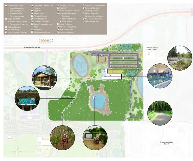
Following a rigorous public input process, Orange County Parks and Recreation along with design consultants created the conceptual design shown below. The park is divided into four zones (Active, Lake, Natural and Passive Recreation), each with its own unique features and planned uses.

Construction is broken out into five planned phases which will occur over a period of many years. Phase I will predominantly consist of infrastructure, access drives and parking, but recreation trails, restrooms and a playground are also planned for the initial phase, which is set to begin construction in late summer 2022. Future phases will include amenities likes splash pad, pickleball courts, disc golf, soccer fields, pavilions, botanical garden and much more.
Draft documents are shown below. For more details and artist renderings of HWRP, pick up your FREE copy of our Horizon West lifestyle and resource guide, available at business locations around town.
Park Access and Hiking Map
HWRP is currently open to the public from dawn to dusk for hiking and equestrian uses only. It can be accessed from a gravel parking lot located on Hamlin Groves Trail at Mann Road. The hiking trails are not marked, but County staff mows them from time to time to keep them clear for use.
Horizon West resident Jerry Blank, a commercial and fine art scenic photographer and hiking enthusiast, has put together incredibly helpful trail maps for residents who would like to explore HWRP in its current, natural state. In the absence of an official map or any trail markings, Jerry has used Google maps and assigned his own descriptive trail names to help hikers on their journey.
The maps give details about what to expect along each route including the distance and notable changes in elevation. Additionally, in a recent Horizon West Happenings Community Group post on Facebook, Jerry advised, “None of the trails are muddy, though some have deep sand or dead vines underfoot. Good hiking footwear is strongly recommended,” so keep that in mind for your first visit!

Enjoy the Beauty of Horizon West
According to his website, Jerry’s “passion is to explore and discover the beauty of this great country of ours, to capture it, and to share it with you.” His efforts to document Horizon West Regional Park certainly live up to that promise!
He has not only marked off several hiking trails with great detail, but he’s even take the time to notate scenic areas, potential hazards and points of interest along the routes.
Jerry has beautifully captured our local flora and fauna and graciously shared images including vibrant passion flower vines, unique prickly pear cacti, a beautiful sunset (above), a colorful rainbow observed shortly after a storm, and an elusive young gopher tortoise!
Share Your HW Regional Park Experiences, too!
We would love to see your photos and learn about your HWRP explorations, too! Show off your hiking achievements, reveal your family’s impressions and help others know what to expect by sharing your experiences with the Horizon West community in our Facebook group or by tagging @HorizonWestHappenings on Instagram.
Special Thanks to Jerry Blank
Horizon West Happenings would like to extend very special thanks to Lakeside Village resident Jerry Blank for not only allowing use of his gorgeous photos in this article, but for sharing his expertise on Horizon West Regional Park with the community. Many residents, including several on our team, have already successfully used these maps to enjoy the park! To see more of Jerry’s detailed exploration of HWRP and his other work, please visit his website.


